Mojave National Preserve is vast. At 1.6 million acres, it is the third-largest unit of the National Park System in the contiguous United States. While much of Mojave’s wild and historic splendor is available only to those who travel its trails and unmaintained roads, the primary roads of the preserve offer endless opportunities for exploration.[weaver_sc id=”breakpic”]
Here’s the “rundowns”:
Caruthers Canyon
Primitive camping, hiking, no signs or services. About 5.5 miles west of Ivanpah Road on New York Mountains Road, then 2.7 miles north on an unsigned road, Caruthers Canyon is located in the rugged New York Mountains.
Surrounded by mountains rising over 7,500 feet, a botanical “island” of chaparral plants remains from wetter times of the past. High clearance and four-wheel drive recommended.
Lanfair Valley
No signs or services. Mojave Desert Outpost, a privately-owned campground, is located here. For information call 951-780-3179. South of the New York Mountains along Ivanpah and Lanfair roads, this high valley shelters an impressive Joshua tree forest and was an early ranching and homesteading center. From 1893 until 1923, the Nevada Southern Railway ran up the valley from Goffs, providing services to homesteaders and ranchers in the valley and to miners in the mountains beyond. While little evidence remains of homesteads that once dotted the valley, tracts of private property still exist. Please respect the rights of landowners.[weaver_sc id=”breakpic”]
Teutonia Peak
Teutonia Peak is a rocky 5,755-foot mountain on the edge of Cima Dome in Mojave National Preserve. The dome, which is 1,500 feet tall and covers seventy square miles, is the most symmetrical dome of its type in the United States. If that geological geometrical fact doesn’t strike your fancy, the hike to the panoramic rocky summit will. It is 3.4 to 4 miles round trip with 700 feet of elevation gain, passing an abandoned silver mine and a thriving forest of Joshua trees along the way to the summit of Teutonia Peak. This information and more at https://www.hikespeak.com.
Kelbaker Road
A 56-mile paved road stretching from I-15 at Baker, Calif. in the north to I-40 east of Ludlow, Calif. in the south, Kelbaker Road winds past cinder cones, lava flows, Kelso Depot, Kelso Dunes, and the Granite Mountains. Cinder Cones & Lava Flows
No signs or services. About 14 miles southeast of Baker, Kelbaker Road traverses a 25,600-acre area of lava flows and volcanic cinder cones thought to range in age from 10,000 to 7 million years old. In 1973, the area was designated as Cinder Cones National Natural Landmark due to its scenic beauty and exceptional geological value.[weaver_sc id=”breakpic”]
Aiken Mine Road
The Aiken Mine (19 miles southeast of Baker, Calif.) offers an interesting side trip through the heart of the area and access to a lava tube. High clearance and four-wheel drive recommended.
It has been suggested that the operators of this mine abruptly shut it down in 1990 and walked away – leaving all of their equipment behind (report is unconfirmed).[weaver_sc id=”breakpic”]
Kelso Depot Visitor Center
Information, exhibits, orientation film, art gallery, bookstore, restrooms, water, picnic area. Open every day but Christmas. Located 34 miles southeast of Baker, Kelso Depot began operation in 1924 and served as train station, restaurant, and employee housing on the Los Angeles and Salt Lake route of the Union Pacific Railroad. Now Mojave National Preserve’s principal information center and museum, the Depot offers extensive exhibits that describe the cultural and natural history of the preserve. Historically furnished rooms offer a glimpse into Kelso’s past.[weaver_sc id=”breakpic”]
Kelso Dunes
Self-guiding trail, pit toilets, no water. About 42 miles southeast of Baker (8 miles south of Kelso Depot), then 3 miles west on a graded dirt road. Nearly 700 feet high and covering a 45-square-mile area, the Kelso Dunes were created over the course of 25,000 years by winds carrying sand grains from the dried Soda Lake and Mojave River Sink located to the northwest. The Providence and Granite mountains served as barriers that trapped the blowing sand. The dunes produce a “booming” or “singing” sound when sand with the right moisture content slides down the steep slopes. Try it for yourself—run down a dune slope (but don’t trample vegetation!) to initiate the sound.
Kelso Dunes represent part of a much larger sand transport system, which includes the nearby Devils Playground region. The composition and morphology of the sand grains indicate that most originated from the Mojave River sink near Afton Canyon, which lies to the west of the dunes’ current location. The sand has accumulated at the southeastern end of the Soda Lake-Kelso basin, where the Granite Mountains and Providence Mountains form a barrier to prevailing winds. At present, only the area around the Mojave River sink and the westernmost parts of Devil’s Playground are receiving new sand through this system; sand is no longer accumulating at Kelso Dunes itself.
Granite Mountains
No signs or services. An imposing jumble of granite marks the south entrance to the preserve, 50 miles southeast of Baker on Kelbaker Road.
Portions of the Granite Mountains lie within the University of California’s Desert Research Center; please respect the signs that mark the boundary. High clearance and four-wheel drive recommended.[weaver_sc id=”breakpic”]
Clark Mountain
No signs or services. The only portion of Mojave National Preserve north of I-15, Clark Mountain is also its highest point, at 7,929 feet. A relic white fir grove near the top is one of only three in the Mojave Desert.
Check detailed maps or ask a ranger for access information. High clearance and four-wheel drive recommended.[weaver_sc id=”breakpic”]
Cima Road
About 26 miles east of Baker, Calif., the paved Cima Road connects I-15 with Cima, Calif., 16 miles to the southeast.
Cima Dome & Joshua Tree Woodland Self-guiding trail, no water. The near-perfect symmetry of Cima Dome rises 1,500 feet above the surrounding desert and is home to the world’s largest concentration of Joshua trees. The top of the dome is located west of Cima Road, this unusual geologic feature is best seen from a distance. Try the view looking northwest from Cedar Canyon Road, 2.5 miles east of Kelso Cima Road.[weaver_sc id=”breakpic”]
White Cross World War I Memorial
Located 12 miles south of I-15 on Cima Road, this memorial is owned and operated by the Veterans of Foreign Wars.
“First erected in 1934, in honor and memory of all military dead of all wars.”[weaver_sc id=”breakpic”]
Cedar Canyon & Black Canyon Roads.
Mostly unpaved, the 20-mile Cedar Canyon Road connects Kelso Cima Road in the west with Ivanpah Road in the east, paralleling (and sometimes joining) the historic Mojave Road. Black Canyon Road (unpaved north of Hole-in-the-Wall) connects Cedar Canyon Road with Essex Road, 20 miles to the south.
Black Canyon Equestrian & Group Campground
Facilities: corrals, pit toilets, trash receptacles, potable water, fire ring, grill, picnic
shelter with tables. Fees: $25 per group per night.
Reservations: required; call 760-928-2572 or 760-252-6104
Located across the road from Hole-in-the-Wall Information Center. Ideal for both large groups and for riders – bring your own horse! Permits required for large groups.
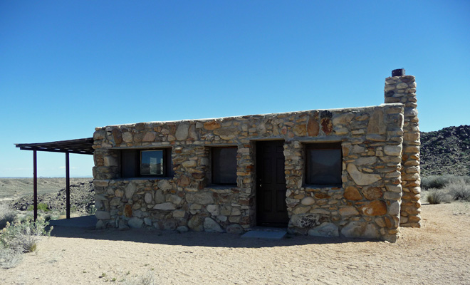
Rock House
Loop trail, wayside exhibits, pit toilet, picnic table. 5 miles east of Black Canyon Road on Cedar Canyon Road.
The Rock House is emblematic of creative desert building styles. Nearby Rock Spring, located along the loop trail, was the site of a military outpost along the Mojave Road.[weaver_sc id=”breakpic”]
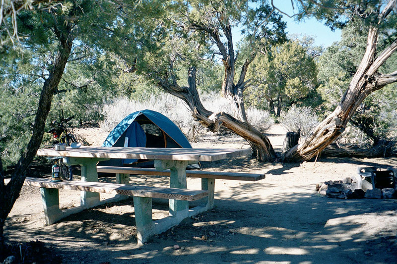
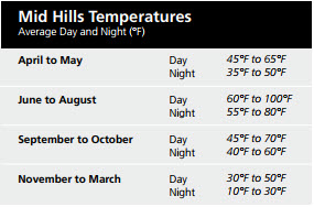
Mid Hills Campground
Campground, trailhead, pit toilets, water. Not recommended for RVs. About 2 miles west of Black Canyon Road at the north end of Wild Horse Canyon Road, Mid Hills supports pinyon-juniper woodland
habitat. The effects of a fire that swept through the area in June 2005 are still evident, although several campsites in the popular campground still contain shady stands of pinyon pine and juniper.[weaver_sc id=”breakpic”]
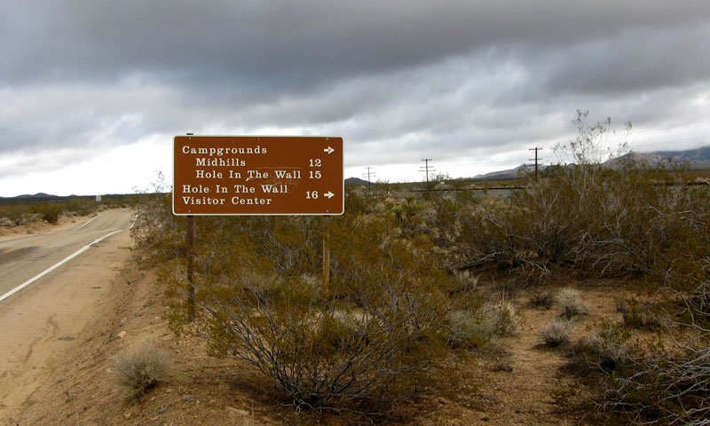
Hole-in-the-Wall Campground
Information center, bookstore, campgrounds, picnic area, trailhead, restroom, water, telephone. Just north of the junction of Black Canyon and the south end of Wild Horse Canyon Roads, rhyolite cliffs riddled with holes and hollows are the backdrop for Hole-in-the-Wall.
About 7.4 miles west of U.S. 95 on the unmarked and unpaved Mojave Road, then 3.1 miles west on an extremely rough unmarked dirt road. High clearance and four-wheel drive recommended.
Fort Piute and Piute Spring Trails, have many wayside exhibits, but no services. Willows, cottonwoods, and rushes thrive along a half-mile section of Piute Creek. Fort Piute (still visible) was one in a string of military outposts built along the Mojave Road. Please don’t climb on the foundations or remove anything.[weaver_sc id=”breakpic”]
Zzyzx Road (w Video)
Six miles southwest of Baker on I-15, Zzyzx Road leads 5 miles south into the preserve along the western shore of Soda Dry Lake. Watch this fabulous video created by the late Huell Howser about this Road and the Soda Springs…and what was the origin of the strangest word ever.
Zzyzx/Soda Springs
Self-guiding trail, wayside exhibits, pit toilets, non-potable water, picnic area. Historically known as Soda Springs and later renamed Zzyzx (pronounced ZYE-zix), this oasis is home to the California State University Desert Studies Center. The buildings and pond were developed in the 1940s by Curtis Springer, who operated a health resort at the site. Zzyzx is open to the public—stroll around Lake Tuendae and along the shore of Soda Dry Lake. Please do not disturb participants when classes are in session.
[weaver_sc id=”breakpic”]
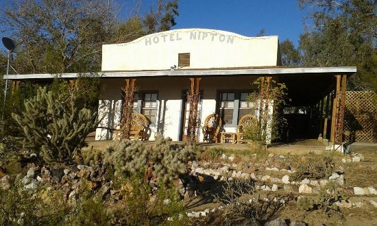
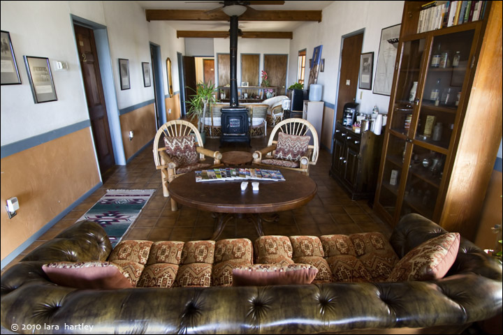
Nipton, Ivanpah & Lanfair Roads
Eleven miles south of Primm, Nev., Nipton Road begins at I-15 and passes through Nipton, Calif., 11 miles east. Ivanpah Road (only the 10 northernmost miles paved) heads southeast of Nipton Road, through the Ivanpah and Lanfair valleys, eventually connecting with the paved Lanfair Road and the Fenner Valley. Together stretching 46 miles, Ivanpah and Lanfair roads connect the northern preserve boundary (bordering Nipton Road) with the southern near Goffs, Calif.

 A 56-mile paved road stretching from I-15 at Baker, Calif. in the north to I-40 east of Ludlow, Calif. in the south, Kelbaker Road winds past cinder cones, lava flows, Kelso Depot, Kelso Dunes, and the Granite Mountains. Cinder Cones & Lava Flows
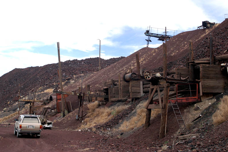 The Aiken Mine (19 miles southeast of Baker, Calif.) offers an interesting side trip through the heart of the area and access to a lava tube. High clearance and four-wheel drive recommended.
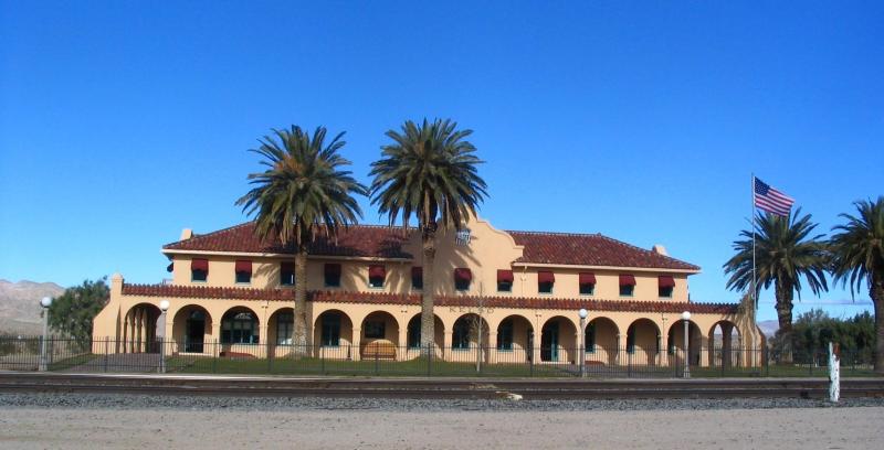 Information, exhibits, orientation film, art gallery, bookstore, restrooms, water, picnic area. Open every day but Christmas. Located 34 miles southeast of Baker, Kelso Depot began operation in 1924 and served as train station, restaurant, and employee housing on the Los Angeles and Salt Lake route of the Union Pacific Railroad. Now Mojave National Preserve’s principal information center and museum, the Depot offers extensive exhibits that describe the cultural and natural history of the preserve. Historically furnished rooms offer a glimpse into Kelso’s past.[weaver_sc id=”breakpic”]
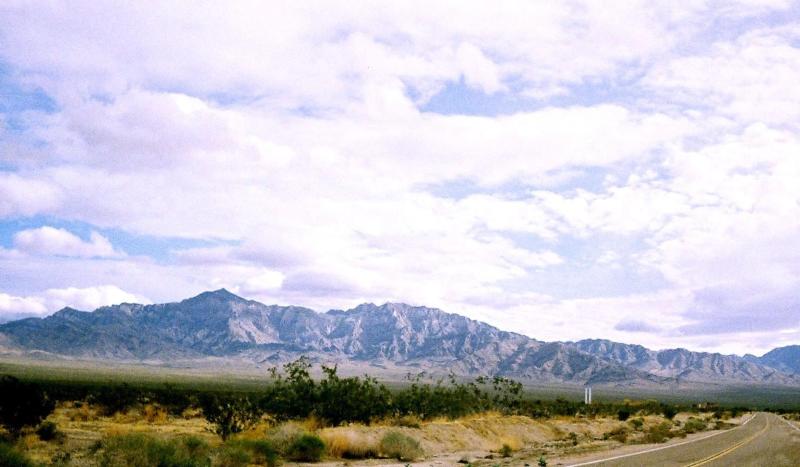 Self-guiding trail, pit toilets, no water. About 42 miles southeast of Baker (8 miles south of Kelso Depot), then 3 miles west on a graded dirt road. Nearly 700 feet high and covering a 45-square-mile area, the Kelso Dunes were created over the course of 25,000 years by winds carrying sand grains from the dried Soda Lake and Mojave River Sink located to the northwest. The Providence and Granite mountains served as barriers that trapped the blowing sand. The dunes produce a “booming” or “singing” sound when sand with the right moisture content slides down the steep slopes. Try it for yourself—run down a dune slope (but don’t trample vegetation!) to initiate the sound.
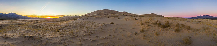
 No signs or services. An imposing jumble of granite marks the south entrance to the preserve, 50 miles southeast of Baker on Kelbaker Road.
 About 26 miles east of Baker, Calif., the paved Cima Road connects I-15 with Cima, Calif., 16 miles to the southeast.
 Campground, trailhead, pit toilets, water. Not recommended for RVs. About 2 miles west of Black Canyon Road at the north end of Wild Horse Canyon Road, Mid Hills supports pinyon-juniper woodland
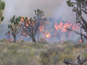

 Information center, bookstore, campgrounds, picnic area, trailhead, restroom, water, telephone. Just north of the junction of Black Canyon and the south end of Wild Horse Canyon Roads, rhyolite cliffs riddled with holes and hollows are the backdrop for Hole-in-the-Wall.
 About 7.4 miles west of U.S. 95 on the unmarked and unpaved Mojave Road, then 3.1 miles west on an extremely rough unmarked dirt road. High clearance and four-wheel drive recommended.